https://www.jpost.com/israel-news/let-it-snow-israel-looking-forward-to-storm-of-the-season-next-week-658746
Aerial view of Jerusalem in snow
(photo credit: ISRAEL POLICE)
Jerusalem may be at least sprinkled in white next week, as forecast models indicate that a cold wave and stormy weather is headed for the Holy Land starting on Tuesday night.
"We're seeing something that hasn't been seen since 2105," Alon Abarbanel, an economics student at Tel Hai and an amateur meteorologist, told Kan on Thursday. "There will be a very cold air system that slides in our direction. We are seeing snow that could accumulate in places like Jerusalem and Metula and not just in the Golan Heights. We're all just waiting for it, especially with the slightly disappointing winter that has been until now. To get the icing on the cake would be amazing."
Meteorologist forums expressed excitement at the possibility of winter weather, with many expressing hope that next week would bring snow to Jerusalem and the mountainous regions of the country.
As of Friday morning, the Israel Meteorological Service (IMS) forecast that early on Wednesday morning, rain showers would begin as temperatures stand at just 41F (5C). The high temperature on Wednesday will be 48F (9C) and the low will be 35F (2C). On Thursday, the high will be 39F (4C) and the low will be just 33F (1C). Throughout Wednesday evening and Thursday morning, the rain is expected to be mixed with snow in a number of locations around Israel, according to the IMS.
Meteorologists stressed, however, that it's still too early for any certainty, as the different models are still unclear and very fragile. According to 02WS -Jerusalem Weather Station, an official forecast will only be possible on Sunday, but, as of Friday, it seems that the peak of the cold wave will arrive until Wednesday evening and Thursday morning, with rain beginning earlier.
The stormy weather may also provide a boost to the already high water levels of the Kinneret, which as of Friday stood at 209.58 meters below sea level, just 78 centimeters below the upper red line which marks a full lake.
The past two years have featured above-average rainfall in Israel, with the Israel Hydrological Service announcing last May that the country had, for the first time in 30 years, experienced its second straight year of such rainfall with 24% more recorded.
The Water Authority is preparing for the possibility that it may need to fully open the Deganya Dam for the first time in 25 years as the Kinneret remains high after two years of especially rainy winters.
If the rainfall this winter exceeds 90% of the perennial average, then the dam will need to be opened. The opening of the dam will likely take place around April 2021 if the water level rises high enough.
The dam was opened partially in 2013, but has not been opened fully since 1995. It had been expected to be partially opened at the beginning of May last year in order to prevent flooding, according to the Kinneret Draining Authority. In April, the Water Authority decided to open a canal to divert five billion liters of water from the Kinneret to the southern Jordan River, with the goal of bypassing the Deganya Dam to avoid negatively affecting pumping stations in the area and the financial costs required to open the dam.
-------------------------------------------------------------------------------------
'Snow apocalypse' batters Moscow
https://phys.org/news/2021-02-apocalypse-batters-moscow.html
Russia's state weather agency has said the depth of snow in the capital could reach or even surpass the record high of 77 centimetres set in March 2013
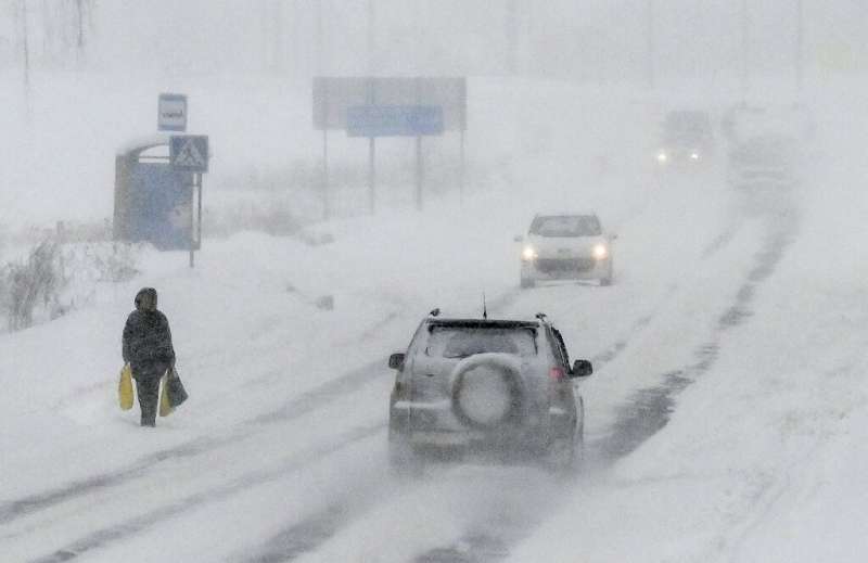
A record-breaking snowstorm descended on Moscow on Friday, paralysing traffic, grounding flights and straining efforts of local authorities to respond to the "snow apocalypse".
Weather experts predict the record-breaking extreme weather will continue over the weekend with winds reaching speeds of 15-20 metres (50-20 feet) per second and temperatures dropping well below freezing.
On Friday, traffic congestion in the city reached a maximum of 10 points according to the Yandex maps service, unusual even for Moscow notorious for its logjams.
The city's transport department urged Muscovites to drive carefully or switch to public transport to avoid the dangerous road conditions.
Moscow's air traffic was affected too, with close to 30 flights reportedly delayed and five cancelled.
Some Muscovites praised the snowstorm.
"There wasn't enough snow in Moscow but now we at least see that there is winter in the city," 42-year-old Vitaly Perevozchikov told AFP on Friday.
Moscow's deputy mayor for housing and public utilities, Pyotr Biryukov, said that the city would do "everything necessary" to ensure traffic does not build up and the sidewalks are clean.
Efforts to clean the streets will continue round-the-clock, he added.

Over 13,500 snowploughs and 60,000 workers have been deployed to deal with the extreme weather
Biryukov told reporters that over 13,500 snowploughs and 60,000 workers had been deployed to deal with the extreme weather.
Earlier this week, Russia's state weather agency, Rosgidromet told AFP that the depth of snow in the capital could reach or even surpass the record high of 77 centimetres set in March 2013.
Rosgidromet spokeswoman Maria Makarova said the snowstorm was a result of a cyclone sweeping down from the north, first picking up cold air that then mixed with hot air over the Black Sea, before turning back up towards central Russia.
Scientists say that as the surface layer of oceans warm due to climate change, cyclones are becoming more powerful and carry more precipitation.
Recommend this post and follow The Life of Earth
https://disqus.com/home/forum/lifeofearth/


No comments:
Post a Comment
Stick to the subject, NO religion, or Party politics