Intense cold is currently engulfing SE Australia as polar air rides unusually-far north on a low solar activity-induced meridional jet stream flow (see links below for more on the mechanisms).
Over the weekend, a myriad of new low temperature records for the month of May were set, most notably at Flinders Island, Lake Victoria and Marrawah.
The extreme fall chill is also proving doggedly persistent, with freezing lows continuing to be logged this morning, Monday, May 31 in Loxton (-3.5C/24.7F) and Lameroo (-1.1C/30F).
Additionally, Melbourne plunged to a low of 1.7C (35F), the capital city’s lowest May reading since 1949.
While the town of Renmark, located in South Australia’s Riverland region, has just suffered its coldest May morning in recorded history when the mercury sank to a truly exceptional five+ degrees Celsius below zero.
The Bureau of Meteorology (BOM) had tweeted a record-breaking low of -4.6C (23.7F) for Renmark airport at 6:10am, but then had to revise it down when the mercury dipped again –to -5.1C (22.8F)— just after 7:00am:
While parts of the Adelaide Hills have also been blanketed by a hard frost Monday morning:
The cold weather led to frosty fields in the Adelaide Hills. (Instagram: barrowandbenchmitre10)
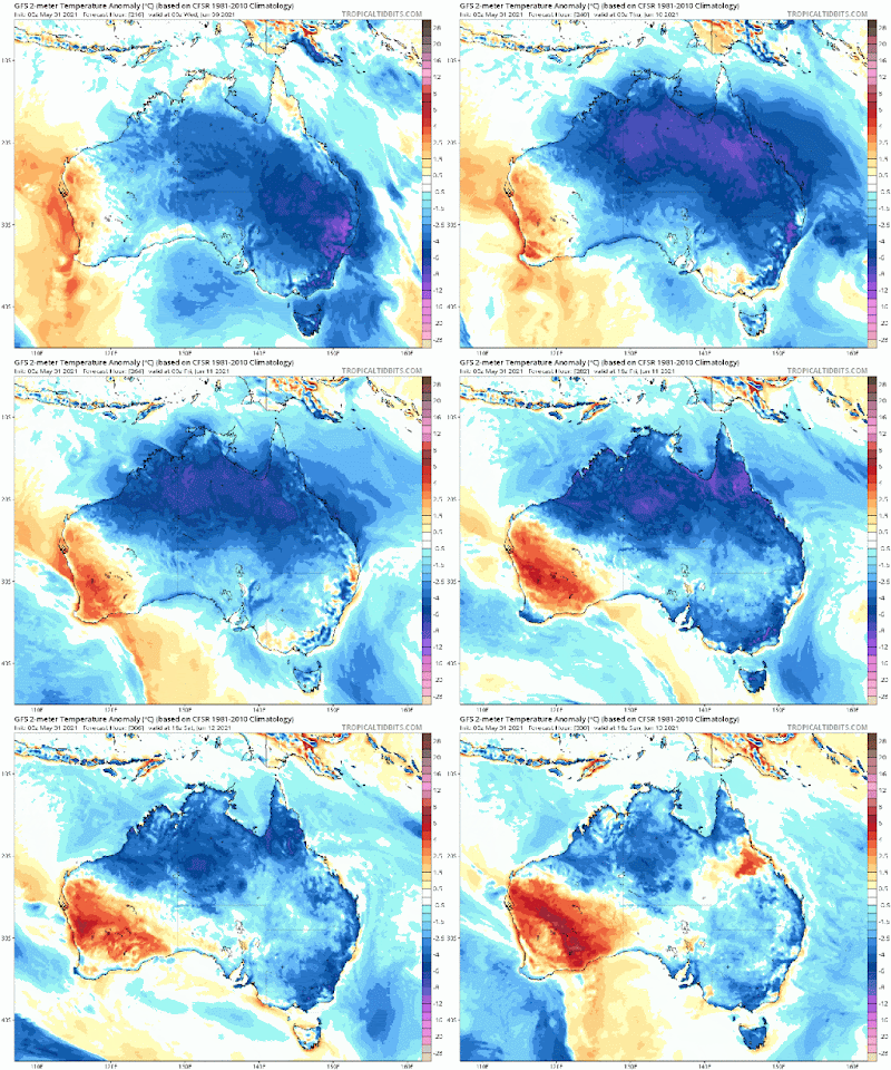
Looking ahead, additional and far more wide-reaching cold looks set to engulf the Aussie continent next week.
According to the latest GFS runs (shown below), frigid Antarctic air will ride anomalously-far north beginning Friday, June 4 which, by June 9, will be delivering temperature departures some 20C below the seasonal average to the majority of Australians:
GFS Total Snowfall (cm) June 8 – June 10 [tropicaltidbits.com].
It is getting harder and harder for the politicized ‘catastrophic global heating’ narrative to be maintained.
But as Gustave Le Bo wrote:
“The masses have never thirsted after truth. They turn aside from evidence that is not to their taste, preferring to deify error, if error seduces them. Whoever can supply them with illusions is easily their master; whoever attempts to destroy their illusions is always their victim.”
According to the decades of dogmatic proclamations handed down by the AGW cabal, weather-related deaths should be rising exponentially as catastrophic global warming ravages the planet.
However, as with most things “alarmist” the data simply doesn’t bear out the fear-mongering.
Figures compiled by injuryfacts.nsc.org (from data provided by NOAA) reveal that the number of direct and indirect injuries from weather events decreased 49% from 2015 to 2019 in the United States, with the number of direct and indirect weather related deaths decreasing 19% over the same period.
Even more telling, the weather event that caused the most deaths in 2019 was actually “winter weather” which resulted in 144 fatalities (verses just the 83 for heat-related deaths).
Winter weather also accounted for the second-highest number of injuries, at 441, with tornadoes taking the top spot that year with 545 (note, there is no sign of heat-related injuries on the list).
The data only runs through 2019, and it will be interesting to see the impact the intensifying cold blasts of 2020 and 2021 have had.
Recommend this post and follow
The birth of modern Man


No comments:
Post a Comment
Stick to the subject, NO religion, or Party politics