Natural, solar-driven global warming is over.
There is no “climate emergency”.
WINTER BITES HARD IN AUSTRALIA
A surge of polar air is set to barrel across multiple Aussies states this weekend, driving temperatures well-below winter norms.
Senior BOM meteorologist Philip Perkins said a severe weather warning will be issued across South Australia, with damaging winds, heavy rain/snow, and anomalous-cold set to blast the state as a series of cold fronts pummel the south/southeast:
(screen shot of twitter vid. CC)
“A system moving through South Australia on Friday is bringing a burst of cold polar air with it,” said Sky News Weather meteorologist Alison Osborne.
“It’s going to be a very chilly end to the week, with low-level snow forecast.”
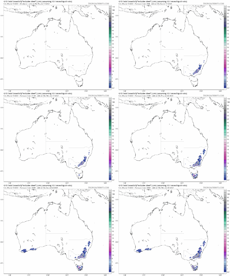
According to the latest GFS run (shown below), that snow looks substantial.
The higher elevations of Victoria and New South Wales are on for something of a burial, with accumulations over a meter possible by the end of next week; while 70% of Tasmania is on course to be buried, too.
Even the southern stretches of Western Australia could see a few flurries, around July 24.
GFS Total Snowfall (cm) July 15 – July 26 [tropicaltidbits.com].
Here’s a closer look at those snowfall totals, expected by July 26:
Farmers in the northern U.S. Plains are on track to harvest the smallest spring wheat crop in 33 years, the U.S. Department of Agriculture (USDA) said this week.
As reported by reuters.com, prices on the Minneapolis Grain Exchange surged more than 5% after the USDA slashed its 2021 spring wheat harvest outlook to 345 million bushels, down 41% from a year earlier and the smallest since 1988.
Soaring U.S. wheat prices will further pinch import-dependent nations that have struggled with food inflation and climbing costs for shipping grain around the world.
“The spring wheat production is a lot weaker than expected and has been heading south. There’s just nothing good to say about this spring wheat crop,” said Jack Scoville, analyst with the Price Futures Group in Chicago.
Delayed plantings due to record cold, persistent drought conditions, and a fierce Pacific Northwest heatwave have all contributed to a disastrous growing season.
The USDA has said that 68% of the Pacific Northwest’s spring wheat was in “poor or very poor” conditions — at this time last year, only 6% of the region’s crop was in such bad shape; and the troubles aren’t just confined to the Northwest — all told, the USDA found that 98% of the U.S. wheat crop is growing in areas hit by drought.
“The general mood among farmers in my area is as dire as I’ve ever seen it,” Idaho wheat farmer Cordell Kress told Reuters. “Something about a drought like this just wears on you. You see your blood, sweat, and tears just slowly wither away and die.”
The USDA is trying to downplay concerns –that’s their job after all, to stabilize the commodity markets– and they are claiming that the U.S. winter wheat harvest will offset some of the spring losses; however, and in the same breath, the Department is bracing us all for tighter wheat supplies, “the tightest in eight years”, in fact–although in reality, supplies will likely be far tighter, the USDA has history here, and in the same report they also rate just 16% of the U.S. spring wheat crop in “good-to-excellent” condition, the lowest early-July level since 1988.
The raw figures speak for themselves.
As always, the spin is, well, the spin.
Food shortages/price-rises are inevitable — grow your own.
MORE ALL-TIME SNOW & ICE GAINS LOGGED ON GREENLAND
On the back of substantial Surface Mass Balance (SMB) gains since 2016 (which coincide with a stark drop in Earth’s average temperature), the Greenland ice sheet is increasing that trend of GROWTH in 2021.
Despite MSM obfuscations, vast regions of Greenland are currently gaining record levels of snow and ice:
Back on May 26, a single day gain of more than 12 gigatons was logged sending the official SMB chart –courtesy of the Danish Meteorological Institute (DMI)– into historic territory, that blue line literally shot off the charts.
And now, this record-breaking growth is continuing into mid-summer.
Yesterday, July 14, Greenland actually gained mass (approx. 2 Gts) — an unprecedented feat this late into the year. Between early-June to early-August the ice sheet experiences its summer melt season, a time when the sheet, on average, loses around 4-6 Gts of mass a day; however, something unexpected is happening this year — the world’s largest island has actually been GAINING between 2-4 Gts of mass all summer:
Again, the raw data speaks for itself.
No spin necessary.
[I would have included another graph here, but the DMI website has just gone down — maybe those historic summer gains needed a little ‘adjusting’…?]
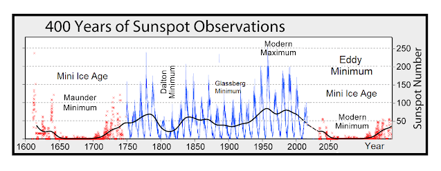
The COLD TIMES are returning, the mid-latitudes are REFREEZING, in line with the great conjunction, historically low solar activity, cloud-nucleating Cosmic Rays, and a meridional jet stream flow (among other forcings).
Both NOAA and NASA appear to agree, if you read between the lines, with NOAA saying we’re entering a ‘full-blown’ Grand Solar Minimum in the late-2020s, and NASA seeing this upcoming solar cycle (25) as “the weakest of the past 200 years”, with the agency correlating previous solar shutdowns to prolonged periods of global cooling here.
Furthermore, we can’t ignore the slew of new scientific papers stating the immense impact The Beaufort Gyre could have on the Gulf Stream, and therefore the climate overall.


No comments:
Post a Comment
Stick to the subject, NO religion, or Party politics