EXCEPTIONAL COLD WAVE SWEEPS 90% OF CHINA–BEIJING SEES SNOW 23 DAYS EARLIER THAN USUAL
An exceptional ‘cold wave’ engulfed the majority of China over the weekend, delivering plunging lows and heavy snows.
On Saturday and Sunday, large parts of China, including Beijing, Tianjin, Hebei, and Inner Mongolia, experienced their first snowfalls of the season, the China Meteorological Administration (CMA) said in a statement.
The cold snap, widely reported as being the earliest and most widespread in a decade (since the solar minimum of cycle 23), is affecting approx. 1.2 billion people and 90 percent of the regions across the country, including the southernmost tropical island of Hainan, where temperatures nosedived at least 8 degrees Celsius, reports globaltimes.cn.
The descending Arctic trough brought blizzard conditions to the north where they were measuring totals in the feet, totals that continue to pose serious challenges to transport, infrastructure, agriculture, and also the energy supply–at a time when much of the Asian continent has already been grappling with shortages.
Across China, authorities are warning people to stay inside and reduce outdoor activities.
Beijing received its first snow of the 2021-2022 season on Saturday — 23 days earlier than the average.
Furthermore, the mercury in the capital broke a 10-year record low.
screen shot only CC
screen shot only CC
Thanks to the climate phenomenon known as La Niña, China is expected to suffer frequent cold waves this winter, warned meteorologists Zhao Huiqiang, an official from the CMA. Many people are fearing a recurrence of the record-setting winter storm that swept southern China in 2008 (solar min of cycle 23). Jia Xiaolong, another official at the CMA, said the 2008 storm was partly caused by abnormal atmospheric circulation, which caused long-lasting snow in a region that does not usually experience severe winter weather. In other words, historically low solar activity weakened the jet streams and reverted their usual zonal flow to a meridional one which, in turn, pulled frigid polar air anomalously-far south:
Arctic air rode anomalously-far south in 2008, delivering rare heavy snow to southern China.
NORTH AFRICA SUFFERS RARE NOVEMBER FLURRIES
Morocco and Algeria have experienced their first frosts and widespread snowfalls of the season.
Remarkable lows of 4.9C (40.8F) were observed at Nado, a coastal city in northeast Morocco.
While rare early-November snow coated North Africa’s higher elevations, including the dunes of Algeria:
Algerian sand dunes in snow [2021].
The cold air sank south from western Europe–a region that has been suffering record low temperatures and exceptionally-early snowfall in recent days, particularly across Spain and Portugal:
https://youtu.be/fLuYtMeuNxQ
Temperatures across France, for example, are on course to plunge a staggering 16C below the season average:
GFS 2m Temperature Anomalies, Nov 14 – Nov 24 [tropicaltidbits.com].
Additional early-season snowfall is also on the cards (see below).
Note the extra flakes forecast for Algeria, too.
GFS 2m Temperature Anomalies, Nov 14 – Nov 24 [tropicaltidbits.com].
CONTINENT-SPANNING POLAR COLD SWEEPS AUSTRALIA
The official start of summer may be just around the corner, but Australian’s have been suffering intense chills of late.
This was the scene Sunday, November 7:
GFS 2m Temperature Anomalies for Nov 7 [tropicaltidbits.com].
Looking ahead, these unusually low temperatures, particularly low-maxes, are forecast to intensify across the entire Aussie continent this week, as are the rains in the east and the snows in the southwest. As reported by theguardian.com, heavy snow down to elevations of 1,000 metres (3,28 feet) is expected in New South Wales, Victoria and Tasmania.
Looking at the latest GFS run (shown below), those ‘blues’ and ‘purples’ –indicating temperature departures of between 6C and 16C below the norm– are projected to engulf every Aussie state over the coming days, from Western Australia to Victoria:
GFS 2m Temperature Anomalies for Nov 11 – Nov 15 [tropicaltidbits.com].
This is looking like a truly exceptional blast of late-spring cold — records are almost certain to fall.
“Australia’s most significant driver of weather patterns, La Niña, is now active for a second consecutive year and will fuel weather systems with moisture for up to six months,” said Sky News Weather senior meteorologist Tom Saunders.
In Australia, La Niñas increase the potential for more storms, wet weather and cooler temperatures, particularly across the east.
In its climate driver update in late October, the Bureau of Meteorology (BOM) was officially on ‘La Niña alert’, one notch away from La Niña being declared; but since then, sea surface temperatures have dropped again.
“Last week, sea surface temperatures across the central equatorial Pacific officially dropped below La Nina thresholds,” said Saunders. “This change in ocean temperatures couples with the atmosphere and leads to a shifting of weather patterns across the entire globe” — yes, alarmists, there are natural forcings capable of such a feat, with the Sun being the most prominent:
“Expect lower maximum temperatures as we move to La Niña,” said BOM senior meteorologist Sarah Scully.
IN OTHER NEWS…
Serving as just one example of the bone-chilling cold to sweep the eastern U.S. in recent days, Lehigh Valley, Pennsylvania, has tied a low-temperature record.
The thermometer at Lehigh Valley International Airport dipped to 23F (-5C) early Sunday, matching a record set in both 2009 and 1954 (solar minimums of cycle 18 and 23, respectively), the National Weather Service reported.
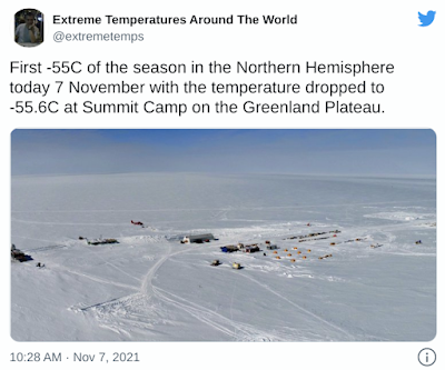
Also, the Northern Hemisphere logged its first -55C of the season over the weekend.
The mercury at Summit Camp on the Greenland Plateau dropped to -55.6C (-68.1F) on Sunday, November 7:
Recommend this post and follow
The Life of Earth


No comments:
Post a Comment
Stick to the subject, NO religion, or Party politics