Turkey
ANOMALOUSLY FRIGID FEBS FOR…
The following averages rely on unreliable ground based temperature stations, which are susceptible to the Urban Heat Island effect–among other issues, including outright tampering; but despite this, many countries still managed to suffer colder than average Februaries.
…AUSTRALIA
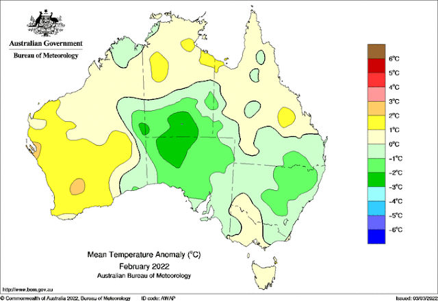
Even the Bureau of Meteorology weren’t able to completely fudge away what was an unusually chilly February 2022 down under.
The Aussie continent finished the month with an average temperature anomaly of -0.6C below the 1991-2020 norm. It was noticeably warm in Western Australia, but that warmth was far outstripped by the those “greens” in the central, southern and eastern parts:
Also, despite pockets of extreme flooding, it was also a dry month; overall, rainfall was 24% below normal:
…JAPAN
February 2022 in Japan was both cold and historically snowy.
The temperature anomaly for the country came out at -0.67C below the 1991-2020 norm.
These persistently frigid conditions are expected to have delayed Tokyo’s cherry blossoming until late March.
…SOUTH KOREA
Last month was extremely cold in South Korea. It was very dry, too.
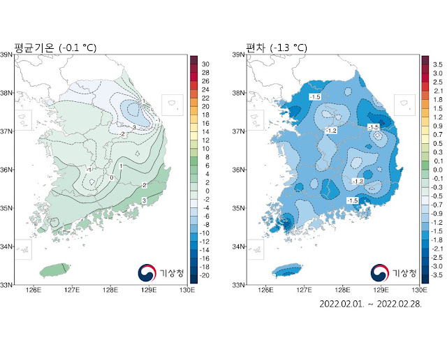
Feb 2022 had an average temperature of -0.1C, which is -1.3C below the 1991-2020 baseline — this freeze drops the overall Winter anomaly (Dec-Feb) to -0.2C below the historical average.
Below maps courtesy of KMA.
…AND HONG KONG
And lastly, February 2022 in Hong Kong was exceptionally chilly, and also wet.
The Administrative Region’s average temperature came out at 15.2C which is a whopping -1.9C below the 1991-2020.
Average rainfall was 168.5mm, a reading more than 4 times the norm.
Below stats courtesy of HK Observatory.
SARDINIA SUFFERS LOWEST MARCH TEMPERATURE EVER
Much of Europe is experiencing a return to wintry conditions, even Mediterranean islands, such as Corsica and Sardinia, are suffering all-time record breaking lows for the month of March.
The mercury in Villanova Strisaili (813m/2,667ft) recently plunged to -11.2C (11.8F) — the lowest temperature ever recorded in Sardinia in March.
GFS 2m Temp Anomalies (C) March 11 [tropicaltidbits.com].
HEAVY SNOW BLANKETS TURKEY, DELAYING ONSET OF SPRING
And likewise in southeastern Europe –and also into the Middle East and southwestern Asia– bone chilling lows and heavy snows continue to disrupt daily life, most notably ACROSS Turkey where full-blown wintry conditions are forecast to persist through mid-March–which is highly unusual.
The Turkish State Meteorological Services (TSMS) warned on Thursday that 63 provinces were exposed to heavy snowfall, rain and strong winds. The snow has seen the closure of a host of schools, and many roads, also including two connecting Antalya and the capital Ankara, reports dailysabah.com, where snowplows and 4,230 personnel are working around the clock in an attempt to keep the streets clear: “You can go home or to work safely,” tweeted Ankara’s mayor, Mansur Yavaş.
According to the TSMS, snowfall will prevail in most regions of the country into the weekend. Turkey’s most populated city, Istanbul, which was exposed to snowfall chaos in January, has also seen sporadic snowfall this week, as well as unusually low temperatures. The TSMS also warned of avalanches in eastern Anatolia and elevated locations of the eastern Black Sea region.
https://youtu.be/xkk7FKVjvms
WINTER WILL HAVE “FINAL, PUNISHING ACT” FOR LOWER-48
A sharp blast of cold is expected to invade the CONUS mid-March, chasing what was a fiercely cold and snowy February…
The NWS says so far this winter The Red River Valley, which stretches across Minnesota and North Dakota, has seen a record-breaking 11 blizzards. That compares to old benchmark of 10, tied by the 2013-14 and 1996-97 seasons. It’s also well above the average 2.6 blizzards during a typical winter. February was also a cold month for the region. The average temperature finished almost 9 degrees (F) below average at the NWS office in Grand Forks. Weather watchers are now keeping a close eye on the next polar front which is forecast to bring further snows and extreme lows to the region this weekend, according to the CPC.
This next system, believe or not, is the more modest of two which are set to plunge into the CONUS over the next 14 days; however, although relatively weak it will still pack a punch and threatens, for example, a 140-year-old cold record in Southern California.
Re that SoCal freeze, and as reported by msn.com: The cold snap has experts pondering how low temperatures would have plunged had a similar atmospheric setup been in place 140 years ago when there were far fewer urban heat island effects. Curious nod to the UHI there…? AccuWeather Meteorologist Ryan Adamson called the upcoming chill “startling for some” in the wake of above-average temperatures (see swings between extremes). The article continues: On Saturday night, AccuWeather is projecting a low within striking distance of the bottom mark for the date of 39-degree set in 1882. Temperatures around the 40-degree mark on Sunday night would tie that date’s record low which has stood since 1893.
But as mentioned above, the second front will prove ‘the biggie’–in both ferocity and scale, and whether you live in Seattle, Washington; Wichita, Kansas; or Washington, D.C., record-breaking cold is on the cards come mid-March:
GFS 2m Temp Anomalies (C) March 8 – March 13 [tropicaltidbits.com].
As are anomalous flurries of late-season snow:
GFS 2m Temp Anomalies (C) March 8 – March 13 [tropicaltidbits.com].
As are anomalous flurries of late-season snow:
Recommend this post and follow
The Life of Earth


No comments:
Post a Comment
Stick to the subject, NO religion, or Party politics