CENTURY-OLD LOW TEMPERATURE RECORDS CONTINUE TO TUMBLE ACROSS CANADA
Arctic air has settled over much of Canada this week, felling a host of cold records across Alberta, B.C. and Sask.:
ALBERTA
Nine record lows were broken in Alberta Thursday morning, adding to the 33 set Wednesday.
Serving as two examples, the Edmonton region, the Stony Plain weather station bottomed out at -23.8C, busting the old record of -21C set in 1966 (solar minimum of cycle 19); while Rocky Mountain House was one of the province’s coldest spots, with Thursday’s -28.9C besting the previous benchmark of -26.7C from 1986 (solar minimum of cycle 21) .
Also worth noting –and not included in the list of record lows below, which comes courtesy of Environment and Climate Change Canada– the city of Edmonton logged -21C this week, making it the metropolitan area’s earliest sub -20C during the first 10 days of November since 1991.
Sundre AreaNew record of -28.1
Old record of -26.9 set in 2019
Records in this area have been kept since 1993
Stony Plain AreaNew record of -23.8
Old record of -21.0 set in 1985
Records in this area have been kept since 1966
Rocky Mountain House AreaNew record of -28.9
Old record of -26.7 set in 1986
Records in this area have been kept since 1915
Barrhead Area
New record of -27.8
Old record of -27.2 set in 1940
Records in this area have been kept since 1912
Whitecourt AreaNew record of -24.4
Old record of -21.8 set in 2019
Records in this area have been kept since 1942
Brooks AreaNew record of -27.2
Old record of -26.0 set in 2019
Records in this area have been kept since 1912
Drumheller AreaNew record of -25.0
Old record of -23.8 set in 2019
Records in this area have been kept since 1923
Esther Area
New record of -28.4
Old record of -27.0 set in 1986
Records in this area have been kept since 1985
Highvale AreaNew record of -24.1
Old record of -21.0 set in 1986
Records in this area have been kept since 1977
B.C.
Thirteen temperature records were toppled –often slain– across B.C. on Wednesday (more fell on Thursday but I have yet to compile the list).
This early onset of polar cold is due, according to Global Okanagan meteorologist Peter Quinlan, to an arctic high-pressure system parked over the Rockies.
“(It) is funneling in the frigid air, pushing an arctic front south of the area,” explained Quinlan. “The result has been record-breaking cold over the B.C. Interior.”
The oldest record broken was in Salmon Arm, which busted the low set more than a century ago, in 1911 (solar minimum of cycle 14–during The Centennial Minimum).
According to Environment Canada records, it seems that the previous comparable cold snap this early in the season was back in 1986 (again, solar min of cycle 21); at least, that’s when the majority of the previous temperature records were set.
I won’t bother listing all 13 fallen benchmarks, just a select few (it’s bloody cold: you get the idea):
Blue RiverNew record of -21 C
Old record of -15.3 C set in 1986
Burns Lake Area New record of -19.2 C
Old record of -19 C set in 1986
Clearwater Area New record of -13.6 C
Old record of -13.5 C set in 1986
Dawson Creek Area New record of -29.7 C
Old record of -28.9 C set in 1986
Mackenzie AreaNew record of -26.6 C
Old record of -23.0 C set in 1986
Sparwood Area New record of -21.4 C
Old record of -20.3 C set in 1986
Squamish Area New record of -3.8 C
Old record of -2.5 C set in 1986
Whistler Area
New record of -11.3 C
Old record of -10.5 C set in 1986
SASKATCHEWAN
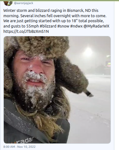
Saskatchewan is also suffering its first brutal Arctic outbreak of the 2022-2023 season, setting four temperature records broken, and tying another, Thursday morning.
Nipawin dropped to -29.9C, breaking its old record by a full degree; Outlook and Rosetown usurped their old marks by nearly two degrees, achieving -26.3C and -29C, respectively; while Kindersley hit -28.9C. Also, Saskatoon tied its old record of -28.9C.
All of the previous records were set in or before 1945, with the oldest being Saskatoon’s tie, set in 1902 (The Centennial Minimum).
A similar freeze is gripping the province as I type (into Friday morning local time). Lows have once again dropped to between -25C and -30C, with the wind chill making it feel even colder. Frostbite will be possible in just minutes, ECCC has warned.
The cold is highly unusual for this time of year.
Kindersley and Rosetown’s high of -18C on Wednesday, for example, was some 20C below normal.
The fiercest chills are forecast to ease through the weekend, but they look set to return next week with added complication snow. Stay tuned for updates.
SNOWFALL BENCHMARKS BUSTED IN NEVADA…
Snow settled over swathes of northern Nevada this week, breaking a 102-year-old snowfall record in the city of Elko.
According to the National Weather Service (see Tweet below), Elko received an unprecedented 3.3 inches of snow on Nov 8, enough to bust the previous record of 2 inches, set back in 1920 (near the end of The Centennial Minimum).
…AND ELSEWHERE
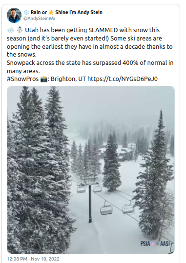
Heavy snowfall is accumulating to the east, too.
Utah’s Atla mountain (pictured below) has already hit 100 inches of snow this Fall–more than a week before opening, too.
[Alta Ski Area]
Over the past three weeks, the resort has seen a flurry of winter storms dump double-digit totals, with 32 inches building over the last 48 hours alone. Alta is also reporting a settled base depth of 62 inches, which is astounding, and record-breaking.
Utah’s statewide snowpack is also performing well-above AGW Party expectations:
It’s early-November, folks — this is not the picture that those corrupt, antihuman puppets at COP27 want painted.
But the above is reality, whereas their degenerative rhetoric is merely a narrative, words designed to undo the advances and prosperity achieved during the past 200 years with their suicidal policy decisions. They want to ‘take back’ the industrial revolution, or more to the point, the cheap and reliable energy and higher living standards that transition delivered; they want us hungry, cold and weak; they want us begging at their feet for table scraps. They want slaves; they want digitized proles.
Fight it.
And fight the cold while you’re at it, too. These next 10-or-so days look frigid-enough, but just look at what the GFS is forecasting for next weekend (Nov 19/20). Those centrally-descending ‘pinks’ indicate temperature anomalies of 20C-28C below the seasonal averages, which converts as sub-zero lows (F) for many states, perhaps even -30F in the extreme. Prepare. Chop wood. Rug up.
GFS 2m Temperature Anomalies (C) Nov 11 – Nov 22 [tropicaltidbits.com].
GFS 2m *Air* Temperatures (F) Nov 19 [tropicaltidbits.com].
Recommend this post and follow
The Life of Earth


No comments:
Post a Comment
Stick to the subject, NO religion, or Party politics