WHERE ARE THE HURRICANES?
The Atlantic hurricane season starts on June 1 and ends on November 30.
As recently as August, NOAA was calling for an “above normal” level of activity. The agency’s updated outlook stated that conditions would likely counterbalance the usually limiting atmospheric conditions associated with El Niños.
 Waters in the Atlantic (where the majority of storms form) are holding warmer than normal with conventional wisdom stating that a “robust” hurricane season should indeed be in order. But at the same time, the developing El Niño increases something called ‘vertical wind shear’ which can tear storms apart as they form.
NOAA bet that this tug-of-war between high SSTs and a burgeoning El Niño would be won by the former, resulting in a hotbed of hurricane sin. But they look to have bet wrong.
The 2023 Atlantic hurricane season has been another quiet one–particularly considering the spurious global boiling rhetoric endlessly pumped through our telescreens. And at the same time, the building El Niño doesn’t appear to a particularly strong event (at least not so far). So what’s going on…? Well, answers on a postcard, because I don’t know.
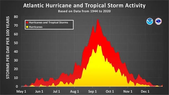
We are now (as of late-Sept) approaching the end of the ‘meaningful months’ and the entire basin is holding remarkably quiet; we are well into the backend descent (see below) and the season is threatening to be yet another that passes uneventfully by.
The Narrative speaks to “a strong correlation between warming ocean temperatures and the number/strength of tropical storms”, it tells of greenhouses gasses “creating more energy for tropical disturbances”.
So I ask again, where are the hurricanes?
HURRICANE DATA SHOW NOW TREND
Experienced data analyst, Zoe Phin, has looked into the the claim that “increasing CO2 emissions are leading to more frequent and intense hurricanes”.
Phin has already dealt with Atlantic hurricanes (linked here), and –SPOILER- found no trend. But here she analyzes the global data.
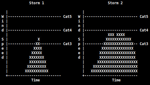
It is definitely true that the number of detected hurricanes has increased, writes Phin. This is due to better sensing technology. But aside from detection there is also a matter of how one counts the frequency of hurricanes. Does it make sense to count a 6-hour Category 3 storm the same as a 42-hour Category 3 storm?
“Storm 1” and “Storm 2” are both classified as Category 3, but the Cat3 status is unequal in time.
Of course it doesn’t, such a thing would be misleading — but that is exactly what the climate cabal do. A far better methodology would be to count the hours spent in certain wind speed categories — and this is exactly what Phin did.
Below are the results from her analysis.
Note: 10yr CMA is 10-Year Centered Moving Average
CATEGORY 1 = CYCLIC/NO-TREND:
CATEGORY 3 = INCREASE, BUT ON THE DECLINE SINCE MID-1990S, WITH CATEGORY 4 = CYCLIC/NO-TREND:
Featured below is the combined data for category 1, 2, 3, 4 and 5 hurricanes.
Overall, no trend is revealed, just natural, cyclic motions — the ‘fingerprints of global boiling’ are not present in the hurricane data. This is irrefutable. The alarmists have backed the wrong pony, as they have a history of doing: polar bears, Greenland ice, the Great Barrier Reef, etc. etc.
COMBINED DATA = NO TREND:
This data shouldn’t be considered contentious — it’s data, honestly collated and logically framed.
SHISHALDIN ERUPTS TO 45,000 FEET
The 12th eruptive episode in just two days culminated in a vigorous eruption at Alaska’s Shishaldin Volcano on September 25.

The explosion was associated with impressive volcanic lightning:
Volcanic lightning during the 12th paroxysm episode at Shishaldin [AVO]
Thus, the Alaska Volcano Observatory (AVO) raised the alert level for the volcano to Red. The National Weather Service has issued a SIGMET for this ash cloud, with an ‘Ash Advisory’ issued for False Pass, and a Special Weather Statement for possible trace ash on Cold Bay, King Cove, and Sand Point.
Activity is still ongoing at the volcano, though at a reduced level — ash ejections to 25,000 feet were noted on Tuesday.
Volcanic eruptions are one of the key climatic forcings that will drive Earth into its next bout of global cooling.
They have been shown to increase in both number and explosivity during times of prolonged solar decline, with one of the mechanisms thought to be tied to an influx of cosmic rays (CRs) penetrating and exciting silica-rich magma. During solar minimums the Sun’s magnetic field weakens and the outward pressure of the solar wind decreases, allowing more CRs to enter the inner solar system, including our planet’s atmosphere.
More cosmic rays = more volcanic eruptions = more atmospheric particulates to block solar energy.
Recommend this post and follow
The Life of Earth


.webp)


No comments:
Post a Comment
Stick to the subject, NO religion, or Party politics