
The global warming narrative is collapsing like a flan in a cupboard. The serial prevaricators are leading the parroting masses ever-closer to that cliff edge, to that ground-shaking revelation that what they’ve been fed for the past four decades isn’t science, but is instead a pile of policy-driving hooey.
SOUTHERN AFRICA:
Winter is arriving early across much of the southern hemisphere, with rare April snow turning parts of Southern Africa into a “winter wonderland,” reports thesouthafrican.com.
Southern Africa’s first wintry dusting of 2021 actually occurred in the enclaved nation of Lesotho back on March 28 — an incredibly early date, said Afriski at the time. Since then, winter has been gaining pace, with a host of additional countries, including South Africa, now bracing for some rare out-of-season accumulations.
“Everything is definitely getting cooler, the light here has completely changed as well,” wrote one Lesotho resident on Twitter, with Afriski tweeting: “Winter has come early this year!”
Ventusky (using the ICON weather model) has reported that some higher elevations of South Africa could receive 6+cm (2.4+inches) of the global warming goodness over the coming days: a “decent amount,” according to official forecasts, especially along the Drakensberg Mountain Range on the Lesotho border.
Latest GFS runs (shown below) appear to support the influx of anomalous cold, with the mercury expected to plunge some 14C below the seasonal average across swathes of he continent as the calendar flips to May:
MAY 1:
 GFS 2m Temp Anomalies (C) for May 2 [tropicaltidbits.com].
MAY 2:
 GFS 2m Temp Anomalies (C) for May 2 [tropicaltidbits.com].
AUSTRALIA:
Aussies have also copped a couple of powerful wintry blasts of late, with further anomalous cold and snow expected this weekend.
Last week began with the southeast suffering a substantial polar outbreak.

(screen cap of tweet)
By Wednesday, April 21, temperatures close to the freezing mark were registered in Tasmania, with the likes of Melbourne and Victoria also suffering unusual cold for the time of year — a staggering -5C (23F) was logged in alpine regions.
The Bureau of Meteorology was forced to issue frost warnings for many elevated regions.
According to reports from News Corp, parts of Victoria got so cold that the “feels like” plunged into negative territory: Mount Hotham and Falls Creek, for example, felt like -7.2C (19F) and -6.2C (20.8F), respectively — incredible feats for the time of year.
Unsurprisingly, out-of-season snow accompanied the out-of-season cold.
Below was the scene at Mt Buller early Wednesday morning:

Mt Buller snow, April 21
Looking ahead, the cold will return and intensify as we enter May.
Intense Antarctic air will push north beginning May 3, and will engulf the southern half of Australia by May 4:
 GFS 2m Temp Anomalies (C) for May 4 [tropicaltidbits.com].
The GFS sees substantial snowfall arriving at around the same time:

GFS Total Snowfall (cm) for May 4 and 5 [tropicaltidbits.com].
Stay tune for updates.
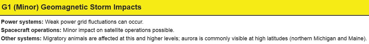
CORONAL MASS EJECTION (CME) UPDATE
As predicted, a CME hit Earth’s magnetic field over the weekend, on April 24 at 2307 UT–so a good few hours earlier than NOAA were predicting.
As well as being early, the impact also underwhelmed: the debris field largely missed us. And while a brief spell of G1-class geomagnetic storms was initiated, the event stopped short of the expected stronger G2-class storms. KP reached 5 for a short time, but the storm is long over, and only minor geomagnetic unrest is likely as Earth exits the CME’s wake.


Recommend this post and follow
The Life of Earth
No comments:
Post a Comment
Stick to the subject, NO religion, or Party politics