https://electroverse.net/slovenia-suffers-coldest-april-temp-ever-belgrade-breaks-all-time-snow-record-european-winemakers-use-frost-fires-antarctic-blast-to-batter-australia/
Frigid air, spilling south from the Arctic and north from Antarctica, has invaded the lower-latitudes of late, throwing the seasons out of whack and breaking long-standing cold records — welcome to the next Grand Solar Minimum.
In Europe, the cold has come as a shock, gripping the continent just days after a brief burst of summerlike warmth. Some areas that experienced their warmest March weather on record last week are now enduring the coldest April weather ever observed (see Grand Solar Minimum and the Swing Between Extremes for more)
Switzerland and Slovenia were among the nations to register record low temperatures for April on Wednesday:
SLOVENIA SUFFERS COLDEST APRIL TEMP IN HISTORY
A new record for the coldest temperature ever recorded in April has been busted in Slovenia.
A reading of -20.6C (-5.1F) was observed at Novi Vasi na Blokah on April 7, at an elevation of 718m (2,355 ft).
This pips the previous record of -20.4C (-4.7F) set in the April of 1956 (solar min of cycle 18), at Rudno Polje.
It also makes it the second national monthly cold record set in 2021.
............ much of long post continues here: https://electroverse.net/slovenia-suffers-coldest-april-temp-ever-belgrade-breaks-all-time-snow-record-european-winemakers-use-frost-fires-antarctic-blast-to-batter-australia/
........ and ends with the following.
ANTARCTIC BLAST TO BRING EARLY-SEASON SNOW TO SE AUSTRALIA
The likes of Sydney, Melbourne and Hobart can expected a “polar blast” of icy air this weekend, sending temperatures plummeting and bringing substantial snow to some regions.
Jonathan How, a meteorologist at the Bureau of Meteorology, said a cold front expected for Friday would be followed by a second front on Saturday, created by a “polar blast” moving north from the Antarctic.
“This is looking to be the last hurrah of the warm season and the summer,” said How.
“The first cold front is a garden-variety cold front. The next one is the leading edge of this air mass moving north from the Southern Ocean. It’s a low pressure system that has been circulating the Antarctic.
“Sometimes we see these systems jump up towards Australia and that’s when we see these winter blasts.
“This will be the last time we see the high 20s and low 30s (degrees C.) until next spring.”
On Sunday the conditions will move through to Sydney, making for a chilly weekend.
“This sudden swing will catch people by surprise,” warns How.
The chill is forecast to bring the first snow falls of the season to the eastern seaboard, with a dusting at 700 m (2,300 ft) in Tasmania, 1,000 m (3,280 ft) in Victoria and 1,200 m (3,940 ft) across the Australian Capital Territory and New South Wales; however, these numbers are according to filthy warm-mongers the BoM, meaning accumulations at lower elevations are entirely possible.
The latest GFS runs reveals the influx of frigid Antarctic air:
GFS 2m Temp Anomalies (C) for April 11 [tropicaltidbits.com].
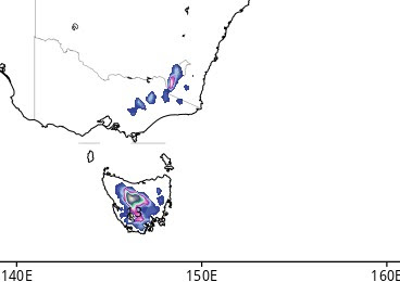
The model is also picking up on impressive early-season snow totals, particularly in Tasmania:
GFS Total Snowfall (cm) April 9 – April 18 [tropicaltidbits.com].
And lastly, today, April 8, our Sun is once again “blank”—-no sunspots are peppering the Earth-facing solar disk:


No comments:
Post a Comment
Stick to the subject, NO religion, or Party politics